

Getting to Know Agistri


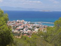
The main harbour of the island is Skala which offers the standard mass tourism features similar to that of Agia Marina in Aegina (ie, lots of touristic places of stay , restaurants, cafes etc). Its village effectively starts beside the harbour’s embarkation point and continues, forming a characteristic ‘nose’, up to where the beach ends at Skala, on the road to Megalochori. The beach is organized in its greater part.

Right behind the main beach is the imposing Church of Saint Anargyroi which stands out from afar with its azure dome. It celebrates on the 1st of July.
In order to continue, we have three choices from Skala. One choice is to go south, following the coastal road towards Skliri. The second choice is to go up south west towards Metochi, and the third is to go along the north west coastal road towards Megalochori.

The road towards Metochi is short (1,100m) and steep. The village is built on the slopes of the hill, on the north east side of the island, and Skala is its seaport. Lovely houses with an unrestricted view towards the sea and the harbour. At the entrance to the village coming from Skala, we can see its cemetery Church Dormition of the Virgin Mary. In the past, it was the centre of the 15th of August celebrations for the whole island. From this point, the view towards Skala, Metopi and Aegina is very beautiful.

In Metochi, on the door of a house surrounded by bougainvillea, a small plaque informs us that the well known German artist Gerti Brauner, lived here from 2000-2010, when she passed away.


We can continue from Metochi on the road that we came up from Skala, passing through the village to meet up with the coastal road that goes in a westwards direction towards Megalochori (2 Km from Metochi). The coastal road is ideal for relaxing walking, especially towards sunset. 300 metres before arriving at Megalochori, we can see on our right the main beachof Megalochori. Beautiful, sandy beach, organized on a part of it. Yet another beautiful beach, this one small and sandy, is the narrow Theris beach right beside Myloi’s harbour.

Megolochori or Myloi is the largest village of the island and its capital. It took the name, Myloi, from the windmills that used to exist in the village. Today, the only windmill of Megolochori that has been saved is renovated and ‘hidden’ on the premises of the homonymous hotel unit. A relief can be made out above its entrance. It dates back to 1812.

We can find several traditional buildings in the village while the Church of Zoodochos Pigi, also the Cathedral of the island, stands out. The basilica with dome was built in 1885 from local tuff stone. It is decorated with iconographs in the renaissance style crafted by Andrianos Stamatiadis. On Good Friday there is a celebratory fair.

200 metres east of the Church of Zoodochos Pigi, we can see a historic small church, of Saint George, the former Cathedral of the island. Only the bell tower reminds us today of the long history of the church (it dates back to before the 19th century). It is said that its floor was paved with Maltese tiles. Unfortunately, nothing is left today.


Opposite the former Cathedral of Saint George, we can make out a small, low, stone building. Here, (in 1814), were placed the bones of 411 fighters of Mitromaras (renowned armatolos and pirate whose real name was Mitros Lekkas or Mitros Dedes), who were slaughtered by the Turks after the failed Orloff revolution in 1772. Monument of Mitromaras is in the churchyard of Saint Anargyroi in Skala.


Leaving behind Megalochori in the direction of Dragonera a detour to our right leads to Karnagio, while to the left takes us south to the beautiful, single chamber, small Church of Saint Pantes situated in the pine tree forest. It has a wonderful view towards Megalochori and the Argosaronic Gulf. The few remains of buildings scattered around Saint Pantes remind us of the old village of the island Palaiochori. From Saint Pantes, a short footpath that goes eastwards leads us to the nearby small Church of Saint Theodoroi.

Returning to the road towards Dragonera, we can see consecutively on the west side, the beaches of Bachos, Mikiri Dragonera and Megalos Dragonera . To reach Bachos, we turn right at the first large dirt road that we meet after about 1 kilometre having left Megalochori in the direction of Dragonera. A few metres on we follow the footpath to the left to arrive at a small bay with two lovely, isolated beaches with fine pebbles. Continuing towards Dragonera, we come again to the asphalt road at about 300 metres, at the point where on our left there is a fallen down bus stop, we stop to follow on our right a beautiful forest path which in 5 minutes takes us to a small beach (isolated with small rocks) of Mikiri Dragonera.
 From the point of our detour towards Mikri Dragonera at another 1,000 metres we arrive at the main beach of Dragonera (the last 300 metres are on an accessible dirt road). Beautiful beach with fine pebbles, verdant green with pine trees. Organized beach that attracts, however, quite a crowd.


We continue from Dragonera towards [Limenaria]. At about 2 kilometres, in a large plateau at Polemi, we can see its old Church of Saint Varvara which was blessed by Saint Nektarios of Aegina. Here were the old threshing areas of the island and the wells made from tufa stone points of collecting water, some of which we can see around the church.


Limenaria is a picturesque, remote village in the south east of the island. Going west at 1.5 kilometres we arrive at Aponissos. The central church of the village is Saint Kyriaki. If we continue from Limenaria eastwards, following the signs for [MarizaMarisa, the road ends after 400 metres and we go down on foot to a very lovely, rocky, isolated beach with deep blue water.

Returning to Limenaria, we follow a westward direction towards Aponissos. At 1,000 metres to our right, we make a stop to visit the cemetery Church of Saint Nikolaos that is built from tufa. Two different old graves inside the cemetery are said to belong to pirates. Opposite the church, on the other side of the road, we can find yet another characteristic old, stone built well.


The road from Saint Nikolaos continues and at 200 metres on our right there appears a lake (yes, there is even a lake in Agistri!). In fact, it is a picturesque wetland that was formerly a salt march. In order to renew and refresh its water a small canal to the sea has been opened. A dirt road encircling the lake has been opened up which we can follow with our means of transport or we can walk it (under 1 kilometre).


Right in front of the small canal, there is a small beach. Clearly, the better beach is the further away Magiza. On the road that goes beside the lake just before we reach the sea passage, there starts to our right a footpath that in about 5 minutes takes us there (300m). It is not as lovely as the beach at Aponissos, Dragonera or Chalikiada (see continuation) but it is ideal for being isolated.


The road stops at another 600 metres from the Lake at a very beautiful location, Aponissos, opposite the small island. Aponissos or Alonissos is today a privately owned island that is connected to Agistri by an improvised bridge. The connection was formerly by means of a floating raft. It has two very beautiful beaches theEast and the West with open, green azure water. On the West beach one can dive from specially shaped rocks, while on East beach there is also a small beach.
Returning back to Skala to follow the last part of our excursion towards its village of Skliri and its beach Chalikiada. From Skala we follow the first choice that we mentioned at the beginning, the south coastal road towards Skliri. Arriving at Skliri, the road continues and if we follow it at about 700 metres it ends at the island’s rubbish dump, at a point however with a very beautiful view towards the sea.

The area of Skliri has developed important touristic facilities with several places to stay built in very lovely pine tree surroundings with a view of the Argosaronic Gulf. Below the village we can enjoy the beautiful green azure water of the Argosaronic Gulf either by diving in from thespecially shaped rocks (below the Hook Club) or from the small beaches that are formed along the coastal line.


Arriving at the limit of the village, a short footpath through the pine trees takes us down to a very lovely small, sandy beach (that is also called Skliri), which cannot however accommodate many people. If we continue on the path, then at 600 metres we arrive at the most impressive beach of the island Chalikiada. With large, white pebbles and green azure water. Going down to this beach is from a height and at one point care is needed, and perhaps help for some. Many holidaymakers camp in their tents in the area (and on the beach).
With this visit to Chalikiada, our tour of the island is completed. Return to Skala and departure for Piraeus, after a tiring but full exploration!


